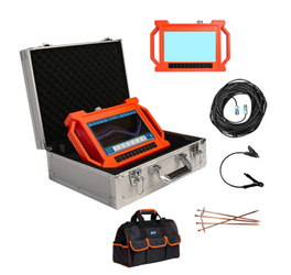
GT500A Geological Water Detector
The GT500A is an advanced multi-channel underground water detection instrument designed for borehole planning, groundwater exploration, geological mapping, and structural surveying. Using natural electric field frequency selection technology and simultaneous multi-frequency data acquisition, it delivers highly accurate results for locating water sources, geological faults, karst caves, mined-out areas, and subsurface anomalies. With real-time automatic mapping and intelligent anomaly analysis, it significantly improves exploration efficiency and decision-making accuracy in the field.
Key Features
-
Real-time automatic curve, profile, and 3D visual mapping
-
One-click automatic abnormal area analysis
-
18-channel simultaneous data acquisition for higher accuracy
-
Supplementary measurement mode for extended geological profiling
-
Stores 999+ survey lines for reporting and comparison
-
Highly stable, multi-frequency natural electric field detection
-
Multi-scenario use: groundwater, cavities, structures, and tunnels
-
Built-in patented data acquisition and processing systems
-
Suitable for geological teams, drillers, surveyors, and hydrology contractors
Technical Specifications
detection depth
-
100m / 150m / 300m / 500m (model-dependent)
max channels
-
18 channels
minimum resolution
-
0.001mV
detection type
-
Electromagnetic (natural electric field method)
display
-
10.1-inch HD LCD
power supply
-
Rechargeable lithium battery
application fields
-
Groundwater detection, borehole drilling, irrigation, mining, tunnel tracing, structural geology
electrodes
-
22pcs
warranty
-
2 years
Applications
-
Groundwater source locating for boreholes
-
Farm irrigation and agricultural water planning
-
Geological structure and fault detection
-
Karst cave and cavity identification
-
Mine vein and tunnel tracing
-
Dam seepage and landslide geological investigation
.png)

